
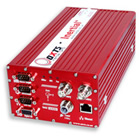
Inertial+ for continuous position and reliable orientation measurements
10th June 2008
Source:
Oxford Technical Solutions
Reliable, continuous positioning is critical for most surveying applications. However, when faced with problematic GPS conditions, such as near buildings or trees, GPS signals are frequently blocked or reflected.
With its newly developed Inertial+, OxTS offers an inertial navigation system that can be used with an existing GPS receiver to improve position measurements. By using a 6-axis IMU, the system is able to measure position and velocity even when GPS is not available. It is able to ignore or correct jumps in the GPS measurements which is ideal when surveying an urban environment.
The Inertial+ is easy to integrate with any GPS receiver model and will not only provide smooth position data but also output measurements like roll, pitch and heading. Data is read and output in NMEA format which is commonly used by many applications.
The Inertial+ includes the inertial sensors, processing engine and the algorithms. All that is needed is a high-accuracy external GPS, which most surveyors already have. By using an external GPS the price of the Inertial+ is significantly lower than fully integrated GPS-aided inertial navigation systems, yet the results are equally good.
Similar articles


More from Oxford Technical Solutions
- New RT2002 GPS+INS system launched 26th March 2010
- Car-to-Pedestrian Tracking 20th August 2009
- OxTS measurement systems used by NHTSA 6th April 2009
- Electronic Stability Control tests with RT2500 4th February 2009


Write a comment
No comments