
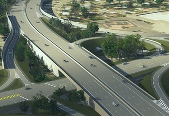
Roadway projects advance from conception through to construction
As a successor to its civil engineering brands; InRoads, GEOPAK, MX, and PowerCivil, Bentley has created OpenRoads Designer CONNECT Edition, and it will be available for early access on 1st December, Bentley Systems has announced. OpenRoads Designer is a multi-discipline 3D modelling application to advance the delivery of roadway projects from conceptual design through construction.
OpenRoads Designer blends traditional engineering workflows for plan, profile, and cross-sections with 3D parametric modelling to enable the model-centric creation of all design deliverables.
OpenRoads Designer supports all aspects of a detailed roadway design including survey, geotechnical, drainage, subsurface utilities, terrain, road, roadway furniture, and more. The incorporation of reality meshes, imagery, point cloud, and other geo-coordinated data sources can provide the continuous context of real-world conditions throughout the design and construction lifecycle.
OpenRoads Designer completes the convergence of InRoads, GEOPAK, MX, and PowerCivil, but adds powerful new innovations, including:
Progressive conceptual design:
Users can directly progress conceptual designs created with OpenRoads ConceptStation, preserving all work and data. (OpenRoads ConceptStation enables rapid conceptual and preliminary design, leveraging existing context captured through reality meshes, point clouds, GIS, and other sources, and creating compelling presentations with engineering precision.)
Contextual design:
All detailed design in OpenRoads Designer is driven by functional components, which inherently respond contextually to express appropriate design, annotation, and plan set display behaviours. Design models are expressed in multiple live views including plan, profile, cross section, and 3D; changes in one view are live and dynamically update all views.
Multi-discipline support:
OpenRoads Designer integrates support for each discipline with specific user profiles dedicated to each discipline. Users can switch discipline perspectives, for instance from Road Design profile to Subsurface Utility profile.
Reality modelling tools:
OpenRoads Designer includes a fully-functioned toolset to incorporate and edit all reality modelling data types, including the capability to extract ground-level features from reality meshes and LiDAR, as well as to reference point clouds and imagery.
Geotechnical tools:
Users can connect directly to gINT geotechnical databases to incorporate subsurface terrain details into their models for improving grading and piling. Subsurface terrains can be generated or modelled based on the bore hole materials and projected in road and drainage profiles, sections, and plans.
Subsurface utilities:
Users can select from a large catalogue of functional components for utility and drainage to model underground drainage and utility networks. Drainage models, moreover, can be optimised for water flow using integrated water analysis tools, with results available in data tables or visually in a profile view.
Rich deliverables:
An expanded set of deliverables range from traditional plan sets and animations to digital construction models—for automated machine control and field positioning systems including for excavation, grading, piling, and paving.
Live Plan generation:
Plan generation need no longer be a separate process limited to a point in time, as settings and annotations are dynamically updated and live in the model. Views are saved with specific display rules and sheet index embedded, making it easy to navigate between model and drawings. Up-to-date drawings can be generated automatically at any time, creating a natural and fluid design environment for both modelling and detailing.
Enlivened visualisation:
OpenRoads Designer provides direct integration to Bentley LumenRT for producing cinematic visualisation, adding vegetation, reflecting nature and climate, and for traffic simulation with VISSIM.
Designs created in OpenRoads Designer benefit from BIM Review through OpenRoads Navigator, in the office, in the field, and at the site. OpenRoads Navigator enables not only visualisation and review of 3D designs, but also status visibility—allowing dispersed teams to progress approvals and the resolution of issues.
Bhupinder Singh, Chief Product Officer, Bentley Systems, said: “OpenRoads CONNECT Edition is the culmination of three decades of Bentley leadership and experience gained from thousands of roadway projects around the world.
Singh added: “We have conscientiously preserved concepts and continuity from GEOPAK, InRoads, and MX—but the BIM advancements in OpenRoads Designer CONNECT Edition are so compelling that we and our users are excited to now take full advantage of this next generation in roadway design software.”
Similar articles


 technology at Jacobs Vehicle Systems.JPG)
More from Bentley Systems, Inc.
- New infrastructure education programme announced 4th May 2021
- Bentley announces Year in Infrastructure 2020 Award Winners 26th October 2020
- Advancing Digital Twins to improve asset performance 16th July 2020
- Year in Infrastructure 2020 Conference goes digital 11th June 2020


Write a comment
No comments