
Supporting critical infrastructure workers during COVID-19
Liverpool-based, Mobile GIS Services (MGISS) is helping maintain critical infrastructure during the coronavirus lockdown with new technology that helps improve field operations with intelligence on hidden assets.
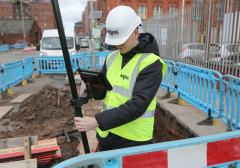
Engineers responding to defects on the highway or problems in the supply of water, electricity and gas are using Augmented Reality to locate and resolve defects and interruptions to supply.
Allowing for the simple, real time capture and display of high accuracy, 3D data compliant with local grids and models, the MGISS Topografi solution is an end to end platform for capturing buried asset data and making it accessible and usable in the field.
Whilst the rest of the country is being asked to stay at home, those with frontline roles in the water, gas and electricity sectors those that are responsible for the highways network are defined as critical workers. Technologies such as satellite positioning systems and rugged field capture devices can ensure geographically accurate data can be captured efficiently, with confidence and in accordance with social distancing rules.
When combined with spatial data management solutions from MGISS, such as the Topografi app, these technologies can ensure up to date information about essential infrastructure is available where and when it is needed to inform real time decision making and maximise resource deployment.
“Now, more than ever, it is essential that highway and utility infrastructure is well maintained and any issues are dealt with in a timely, effective, yet safe manner,” commented Mike Darracott, Founder and Managing Director of MGISS. “The geospatial community has a role to play supporting those workers that are still out there making sure our transport system continues to operate for essential journeys and there is continuity of service in the water, gas and electricity sectors.
“Easy access to usable, accurate and up to date information will help underpin the planning of routine works and the response to emergency call outs whilst, of course, observing safe working practices,” he continued.
MGISS is already supporting organisations such as the Northumbrian Water Group to improve the accuracy and currency of asset data, future proof corporate systems and to support investment in augmented virtual reality visualisations and digital twin projects.
MGISS has also worked alongside Highways England contractor Sir Robert McAlpine to implement a highway asset system with a bespoke condition inspection app and Surrey County Council Highways to deliver productivity gains and resource efficiencies.


Write a comment
No comments